
The Land of Pioneers Trail:
A Walk Through History in Arizona's White Mountains
Discover Arizona’s Land of Pioneers Trail. Nestled in the scenic White Mountains, this trail offers a unique journey into America's western history.
There's a profound mystery wrapped in the beauty of Arizona's landscapes, a call from the past that echoes amidst the mountain ranges. Located deep in the heart of the White Mountains, the Land of Pioneers Trail is a unique exploration of this state's captivating history and breathtaking natural allure.
Location and Directions:
The Land of Pioneers Trail is nestled in the majestic White Mountains of eastern Arizona. This region is approximately a three-hour drive from the urban heart of Phoenix, and two hours from the picturesque, historical city of Flagstaff.
From Phoenix, take US-60 E and US-191 N to your destination in Eagar. The trailhead starts at Ramsey Park, located in the northern part of Eagar.
From Flagstaff, you’ll head east on I-40 E before taking exit 286 for US-191 S, which will lead you straight to Eagar.
Parking is available at Ramsey Park, and from there, the Land of Pioneers Trail unwinds into the wilderness, just waiting for your adventurous spirit.
The Trail Experience:
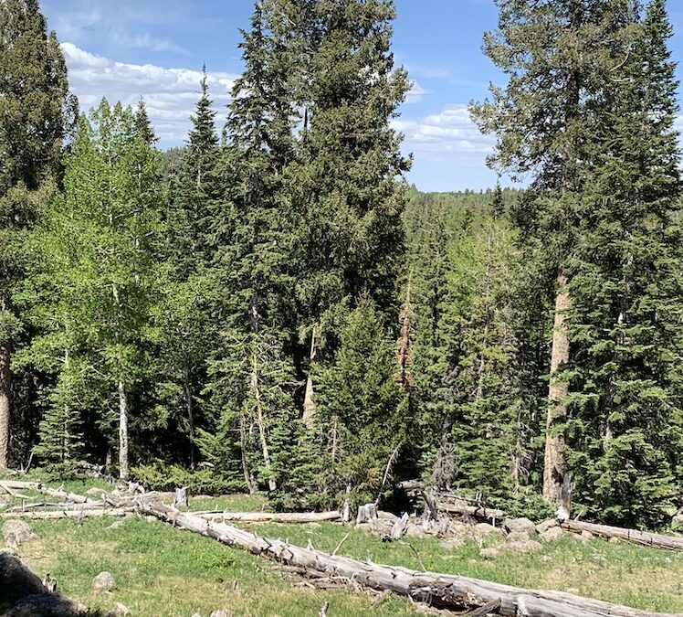
Offering more than a simple walk amidst nature, the Land of Pioneers Trail is a thematic journey into Arizona's pioneering history. Marked by informative plaques and landmarks, this trail lets you relive the days of Arizona's early settlers, their challenges, triumphs, and undying spirit.
This moderate trail spans approximately 5 miles and is well-suited for hikers of all skill levels. The journey will take you through rolling meadows, tranquil forests of Ponderosa pines, and offers stunning views of the surrounding mountains.
Wildlife enthusiasts can delight in spotting local species like elk, deer, and an array of bird species that make these mountains their home.
Why is it Popular?
The Land of Pioneers Trail is more than just a trail; it’s a living, breathing history book set amidst some of the most beautiful landscapes in Arizona. Here are a few reasons why it's a favorite among locals and tourists alike:
1. Educational Value: The trail tells the tale of the pioneers who ventured into this wilderness, offering fascinating historical insights. It's not just a hike; it's a history lesson enveloped in a nature walk.
2. Scenic Beauty: Few trails offer the variety and sheer beauty of the Land of Pioneers Trail. The changing landscape keeps every step interesting, from the dense forests to the open meadows and sweeping mountain views.
3. Wildlife Encounters: The trail is a prime spot for wildlife sightings, making it a favorite for nature photographers and wildlife enthusiasts.
4. Accessibility: The trail is well-marked, maintained, and suitable for hikers of all skill levels, making it a great choice for families and solo adventurers.
Conclusion:
The Land of Pioneers Trail in the Arizona White Mountains offers an adventure that is educational, inspiring, and breathtakingly beautiful. Whether you’re a history buff, a nature lover, or a seasoned hiker seeking your next adventure, this trail invites you to discover a piece of Arizona's past and present that you won't soon forget.
Details:
The hike to the cabin site along the trail is just over a mile. The first ruins appear at location marker L30 and the main cabin ruins are a quarter mile farther at marker L29.
This is also where the shortcut for Loop 1 veers off for a 3.5-mile option. Next on the big loop, look for a short spur path on the left near marker L26 that leads to Section 31 Tank. The secluded water hole atracts multicolored dragonflies.
After another 0.75 mile, the trail traces the edge of a rocky box canyon with steep drop-offs and first glimpses of dozens of eroding cinder cones in the Springerville Volcanic Field. This is one of the prettiest spots on the trail. Beyond the canyon, the trail begins its ascent up the flanks of Ecks Mountain.
To bypass this challenging section, take the signed shortcut for a 6.8-mile moderate trek. Sweat expended on Ecks Mountain and an optional short spur that leads to a vista point pays off with excellent panoramic views of Greens Peak and rolling prairies that stretch into New Mexico.
A set of tight switchbacks mitigates the vertical descent down to the south leg of the loop. The final miles back to the trailhead undulate through boulder-studded ravines, moist drainages and fields of wildflowers shaded by the afternoon clouds that roll in like clockwork. Be prepared for storms on summer afternoons.
Length: Circumference Loop, 8.7 miles. Loop 1, 3.5 miles. Loop 1-2 combo, 6.8 miles.
Rating: Moderate.
Elevation: 7,220-7,864 feet.
Find Map, Downloadable Detailed Description, and GPS Coordinates Here: